

The Woodlands Township Elections November 2022
Transportation Improvements in The Woodlands
Since its founding in 1974, The Woodlands has steadily grown into a thriving community in which over 115,000 people live and roughly 64,000 are employed. Amazingly enough, through all of this development The Woodlands has managed to maintain a land ratio of 28% green space (that’s 5% higher than George Mitchell’s original vision for The Woodlands intended). This combination of urban development and conservation of the natural environment has developed The Woodlands into one of the most highly rated places to live and work in America, making its homes highly sought after and increasingly more valuable. With one of the lowest crime rates in the US and relatively low tax rates in comparison to similarly sized cities in Texas, there is not much for residents of The Woodlands to complain about…that is besides traffic.
As increasingly more people begin to live and work in The Woodlands every day, it makes sense that the roads are becoming more and more congested. With The Woodlands approaching buildout capacity, Montgomery County Precinct Three’s commissioner James Noack hired third party Brown and Gay Engineers to conduct multiple studies on the flow of traffic in and around The Woodlands, and how it could be improved. Commissioner Noack’s South County Mobility Study (Sept 2015) discovered that many of the main thoroughfares in and around The Woodlands are experiencing traffic at a level that exceeds the capacity of the existing improvements. Within The Woodlands, the required improvements including grade separations at major intersections and pavement widening are in the plan and can be accommodated within the existing right-of-way dedicated to the county, but have not yet been implemented due to lack of funding. However, the existing interchanges along IH 45 at Woodlands Parkway/Robinson Road and Lake Woodlands Drive which are outside The Woodlands are rural designs which have become obsolete as the area has developed into an urban area. The study warns, “Inadequate transportation facilities and services in the SCMP study area threaten the quality of life enjoyed by current residents as well as [The Woodlands’] continued economic growth.”
By updating signal timing, installing flashing yellow arrows where permitted, adding time-of-day plans to account for churches and schools, putting in different time-of-day plans for peak and non-peak hours, and decreasing cycle length, the office of the commissioner was able to decrease a majority of the wait times at lights on Lake Woodlands, Research Forest, Gosling Rd and Woodlands Parkway.
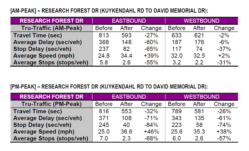
These timing adjustments efficiently improved congestion in the short term at little cost.
Another way the flow of traffic in The Woodlands could be improved is by reducing the actual number of vehicles traveling on the roads. The Woodlands Origin-Destination study utilized portable Bluetooth devices in vehicles, built-in Bluetooth devices at stoplights, and traffic counts from pneumatic tubes to identify traffic flow patterns coming to and from The Woodlands area. It concluded that roughly 12,400 vehicles a day cut through The Woodlands from one side to the other, adding a significant amount of traffic to its roads while contributing little or nothing to its economy. Not only does this cut-through traffic steal minutes out of residents’ and workers’ valuable time each and every day they use the roads in The Woodlands, it raises the average number of stops on a drive, which decreases fuel efficiency and in turn leads to more money spent at the gas pump. In order to divert this through traffic and cut down on congestion, the study recommended the development of “The Woodlands Loop.”
The Woodlands Loop would utilize federal, state, and local government funding to improve the connectivity and flow of traffic between approximately 34 miles of existing roads that surround The Woodlands including Interstate 45, Texas 242, FM 1488, FM 2978, Hufsmith Kuykendahl Road and the Grand Parkway.
The recommended improvements entail:
- Widening FM 1488 from four lanes to six between Interstate 45 and FM 2978
- Widening FM 2978 from two lanes to four with a two-way continuous turn lane and wide shoulders for bicycles
- Widening I-45 or constructing an elevated expressway to accelerate traffic bypassing The Woodlands and alleviate congestion at the Rayford/Sawdust, Woodlands Parkway and Research Forest exits
If the connectivity and flow of traffic between the roads that compose the loop are improved, then it will become faster to drive around The Woodlands than driving through. Theoretically, people traveling from one side of The Woodlands to the other would choose to take this longer but faster route, resulting in significantly less congestion inside The Woodlands during peak traffic hours.
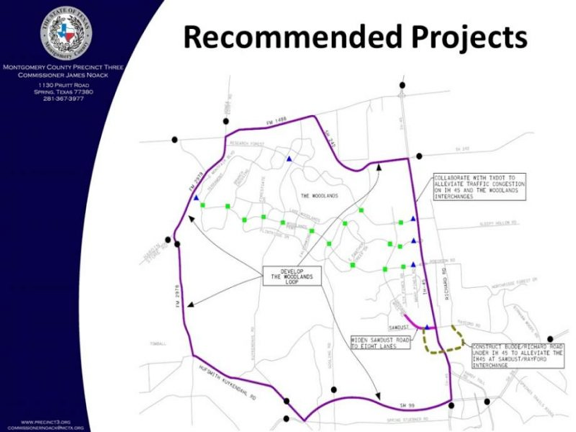
In addition to the development of The Woodlands Loop, the study also recommended:
- Widening Sawdust road from I-45 to Sawmill/Sawdust road to eight lanes
- Widening Grogan’s Mill from Sawdust to Woodlands Parkway to six lanes (currently underway)
- Constructing a horseshoe from Budde/Richard Road circling under I-45 and looping back to Rayford Road to alleviate traffic at the interchange of I-45 and Rayford/Sawdust


